

Files
Download Full Text (8.7 MB)
Description
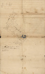
There are two hand-drawn surveys of land along the edge of Wolf Harbor swamp, in present-day Newark. The land was owned by Peter Van Brugh Livingston and John Stevens. A document is labeled Memorandum of Lands at Wolf Harbor - Raway [Rahway] River and Salt Meadow, October 29, 1964. Another is labeled Lands Near Newark and a Track on Raway [Rahway] River Belonging half to Peter V. Livingston and the other half to John Stevens, N. 36. All the documents are related to Wolf Harbor, but it's not known if they were created at the same time. Documents include the acreage and location of nearby landowners.
Names included: Judah Pennington, Jason Johnson, Jasper Crane, Mr. Bratten, James Brown, John Ward, Samuel Pennington, Samuel Tomkin, Jean Treat, John Wall, John Stevens, John Baldwin, Tomkins David Smith and his sister, Issac Lyon, Benjamin Co. and Samuel Allen, David Ogden, Jonathan Crane, Samuel Nutman, John Lyon, Mr. Alexander, Solomon Crane, Harrison, Lewis Ashfield, and James Nutman.
Author/Creator
Peter Van Brugh Livingston
Creation Date
circa 1764
Creation Date
10-29-1764
Document Type
Manuscript
Inventory Location
103 C
Recommended Citation
Livingston, Peter V.. Peter Van Brugh Livingston and J. Stevens, Wolf Harbor, October 29, 1764. Manuscript. From Special Collections Research Library and Archive, Kean University, Liberty Hall Collection 1760s. https://digitalcommons.kean.edu/lhc_1760s/7
Rights
This collection is open to the public for research use. Copyright remains with Kean University. Credit this material. Personal photographs may be made for research purposes. Inquiries regarding publishing material from the collection should be directed to the Special Collections Research Library and Archive at keanscrla@kean.edu.
Publishing Repository
Special Collections Research Library and Archive, Kean University
Collection
Liberty Hall Collection, 1711-1847 (bulk 1790-1830)